
Paper 3
Advanced Physical Geography Options 1 hour 30 minutes
Candidates answer questions on two of the optional topics.
Each topic consists of one structured question (10 marks) and a
choice of essay questions (20 marks).
60 marks
– 25% of the total A level qualification.
9.2 Hazards resulting from mass movements
The nature and causes of mass movements and resultant hazards
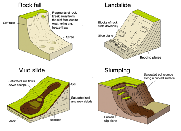
Mass movements are generally classified according to their speed of movement and the amount of water present. It is also possible to distinguish between different types of movement: falls, slides, flows, slumps.
Visit this site and make notes on the different types of mass movement then complete the quiz at the bottom of the page.
A particular area of interest with regard to mass movement is the Caribbean. Tropical storm activity is likely to be a significant reason for this as they trigger landslides. The annual repair cost for roads in the Caribbean is estimated to be in the region of US$15 million.
- In Jamaica in 2001, tropical storm Michelle triggered debris flows, many 2-3km in length.
- In Nicaragua was impacted by storm Mitch in 1998. A mudflow was created that was 20km long and 2-3km wide, which killed more than 1500 people.
There are a number of human activities that increase the risk of landslides:
- increasing the angle of slope – this happens where people cut through high ground increasing instability
- placing extra weight on slopes – this is done by building which adds to the stress
- removing vegetation – roots bind the soil together so taking vegetation away removes this stability. It also reduced interception increasing the amount of moisture making it into the soil
- exposing rock joints and bedding planes – this increases the speed at which weathering occurs.
There have been a number of attempts designed to manage the landslide risk including producing hazard maps for the region. Other methods are labour intensive and include:
- building restraining structures – walls, piles, buttresses and gabions all of which may hold back minor landslides
- excavating and filling steep slopes – making a slope more gentle can reduce the impact of gravity on a slope
- draining slopes – reducing the build up of water decreases water pressure increasing stability
- watershed management – afforestation and agroforestry will increase interception reducing the amount of water reaching the soil and reducing overland flow.
Many informal settlements are constructed on land at risk of landslides due to the fact that the land is not a popular choice for better developments.
How can human activity increase the risk of landslides? [6 marks]
Case Study: Landslides

Puerto Rico, 1985
- 70-80% hilly or mountainous
- Average annual precipitation from below 1000mm along the southern coast to over 4000mm in the rainforest areas in the north-east.
- PR gets twice as much rain between May and October as it does in the rest of the year
- In October 1985 a storm which turned into tropical storm Isabel produced extreme rainfall
- Puerto Rico has three main physiographic regions: the mountainous interior, the coastal lowlands, and the karst area. The mountainous interior is formed by a central mountain chain known as the Cordillera Central in the west and the Sierra de Cayey in the east.
- The upland mountainous area commonly has slopes as steep as 45°.
- Although most development is in the more gently sloping areas, population growth has pushed development into the Upland and Northern Karst provinces
The tropical storm in October 1985 triggered thousands of debris flows as well as a disastrous rock slide that destroyed the Mameyes district of Ponce, killing at least 129 people. This was the worst ever landslide experienced in Puerto Rico. More than 100 homes were destroyed and about as many were later condemned and removed because of continuing risk from landslide hazards.
The greatest cost to public works in PR is road maintenance. The long-term average of around 5 fatalities per year, 10s of houses are destroyed and hundreds are damaged by landslides each year.
Using the above information, suggest why Puerto Rico is vulnerable to landslides and suggest how the threat of landslides could be reduced.
Case study: Mudslides
What are the natural reasons why Sierra Leone is vulnerable to mudslides? What human factors have increased the risk?
Avalanches
Mass movement of snow and ice
1.What is an avalanche? 2.What causes avalanches?

Avalanches can be classified in a number of ways:
- airborne powder-snow avalanches or ground hugging avalanches
- the type of breakaway – a point formed with loose snow or an area formed of a slab
- position of the sliding surface – the whole snow cover or just the surface
- water content – dry or wet avalanches
- the form of the avalanche – whether it is channelled in cross-section or open
Avalanches cannot be prevented, but their impacts can be reduced:

Using the European Avalanches case study answer the following:
- What are the factors that increase the risk of an avalanche?
- What were the conditions in Europe in February 1999 that led to widespread avalanches?
- How and why may the threat of avalanches change in the next decades?
- Study figure 9.30 and 9.31
- Describe the site of Montroc and Le Tour.
- What attractions for tourists are shown in the map. Use grid references to locate the attractions.
- What is the map evidence to suggest that the area is at risk of hazardous events?
Prediction and Hazard Mapping
Careful analysis and planning, alongside appropriate stabilisation techniques, can allow the impacts of mass movement to be reduced or even eliminated.
Assessment of the hazard is usually based on past events – looking at the size of the events and the frequency with which they occur. Mapping and testing of soil and rock type and properties can also help determine their susceptibility to destabilising processes. Maps showing areas at risk are important tools for land-use planners.
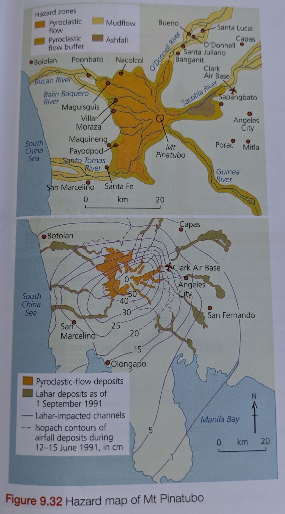
The Valleys in the Cascade Mountains have experienced extensive mudflows and the mapping associated with these, due to their links with volcanic activity, was particularly useful during eruptions of both Mount St Helens and Mt Pinatubo as the mudflows created by the eruption had similar distributions. This allowed their impact to be minimised and probably saved lives.
Engineering schemes that can be used to reduce the damage are:
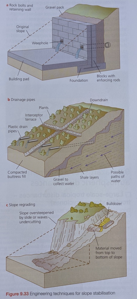
- Retaining devices
- Concrete blocks or gabions may be used to strengthen slopes
- Drainage pipes
- Slopes subject to creep (slow mass movement) can be stabilised by draining or pumping water from saturated sediment
- Grading of slope
- Regrading slopes to make a steep slope more gentle
- Diversion walls
Reducing or eliminating human activities in areas which are susceptible to mass movement is likely the most effective way to reduce damage and limit the loss of life. Recreation or parkland may be a viable choice of land use in areas susceptible to mild movement, but it would be unwise to use the land for residential or industrial use. Monitoring weather activity can also help.
Past Paper Exam Question
7 Fig. 7.1 shows some types of mass movement.
(a) Describe the characteristics of the debris flows and the mudflow shown in Fig. 7.1. [4]
(b) Explain why the hazardous nature of the types of mass movements shown in Fig. 7.1 varies.
[6]

c. ‘The hazardous impacts of mass movements depend on their nature and causes.’
With the aid of examples, how far do you agree? [20]
